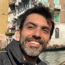
MAURICIO CORDEIRO
GEOSPATIAL DATA SCIENTIST
SCIENTIFIC PROGRAMMER
Data scientist and scientific programmer, specialized in geosciences and remote sensing for environment. Deep learning practitioner.
More than 15 years of experience working at the IT department of the Brazilian National Water Agency (ANA).
Currently on the last year of PhD on the Géosciences Environnement Toulouse (GET) laboratory, Université Paul Sabatier (UPS), Toulouse, France.
Passionate writer and educator. Check out my articles on Medium (http://cordmaur.medium.com).
Want to contact me?
e-mail: [email protected]
Click on the category
Deep learning articles published on Medium
| Title | Link |
|---|---|
| A simple cloud-detection walk-through using Convolutional Neural Network (CNN and U-Net) and Fast.ai library | AV |
| How to create a custom Dataset / Loader in PyTorch, from Scratch, for multi-band Satellite Images Dataset from Kaggle | AV |
| Creating a Very Simple U-Net Model with PyTorch for Semantic Segmentation of Satellite Images | AV |
| Creating training patches for Deep Learning Image Segmentation of Satellite (Sentinel 2) Imagery | AV |
| How to create a DataBlock for Multispectral Satellite Image Segmentation with the Fastai-v2 | TDS |
| How to implement augmentations for Multispectral Satellite Images Segmentation using Fastai-v2 and Albumentations | TDS |
Publications: AV - Analytics Vidhya | TDS - Towards Data Science
Programming / Remote Sensing articles published on Medium
| Title | Link |
|---|---|
| Organizing Geospatial data with Spatio Temporal Assets Catalogs — STAC using python | TDS |
| Creating Sentinel 2 (Truly) Cloudless Mosaics with Microsoft Planetary Computer | TDS |
| How to Download Assets from Google Earth Engine (GEE) and Overcome the Size Limitations | AV |
| Leveraging the Performance of Agglomerative Clustering for High-Resolution Satellite Images | AV |
| Water Detection in High Resolution Satellite Images using the waterdetect python package | TDS |
| Python for Geosciences: Working with Satellite Images (step by step) | AV |
| Python for Geosciences: Satellite Image Analysis (step by step) | AV |
| Python for Geosciences: Spectral Analysis (step by step) | AV |
| Python for Geosciences: Raster bit masks explained (step by step) | AV |
| Python for Geosciences: Raster Merging, Clipping and Reprojection with Rasterio | AV |
| Python for Geosciences: Scatter Plots and PDF reports | AV |
| How to Implement Sunglint Detection for Sentinel 2 Images in Python using Metadata Info | TDS |
| A Python Framework to Retrieve and Process hyperspectral field measurements from TRIOS sensors | TDS |
Publications: AV - Analytics Vidhya | TDS - Towards Data Science
Finance and Algo Trading articles published on Medium
| Title | Link |
|---|---|
| A Step-by-step Implementation of a Trading Strategy in Python using ARIMA + GARCH models | AV |
| Comparing the performance of LSTM vs ARIMA+GARCH on the S&P500 stock index | AV |
| Understanding and Implementing Kalman Filter in Python for Pairs Trading | AV |
| Implementing a Simple Mean Reverting Pairs Trading Algorithm in the Quantconnect platform (Part 1) | AV |
| Implementing a Simple Mean Reverting Pairs Trading Algorithm in the Quantconnect platform (Part 2) | AV |
| How to backtest Quantconnect’s (LEAN) strategies locally using Yahoo data and Python | DDI |
Publications: AV - Analytics Vidhya | TDS - Towards Data Science | DDI - Data Driven Investor
| References |
|---|
| Cordeiro, M.C.R., Martinez, J.-M., Peña-Luque, S., 2021. Automatic water detection from multidimensional hierarchical clustering for Sentinel-2 images and a comparison with Level 2A processors. Remote Sensing of Environment 253, 112209. https://doi.org/10.1016/j.rse.2020.112209 |
| Peña-Luque, S., Ferrant, S., Cordeiro, M., Ledauphin, T., Maxant, J., Martinez, J., 2021. Sentinel-1&2 Multitemporal Water Surface Detection Accuracies, Evaluated at Regional and Reservoirs Level. Remote Sensing 13, 3279. https://doi.org/10.3390/rs13163279 |
| Barbosa, S.A.; Cordeiro, M.C.R; Silva, M.A; et. al., 2014. Atlas Geográfico de Recursos Hídricos do Brasil. Brasília: Agência Nacional de Águas. http://fliphtml5.com/txxn/aeve/basic |
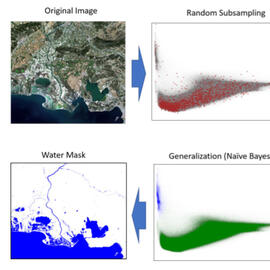
Water Detect
Unsupervised algorithm to generate open water cover masks, specially conceived for L2A Sentinel 2 imagery, based on multidimensional clustering. without any a priori knowledge on the scene.
https://github.com/cordmaur/WaterDetect
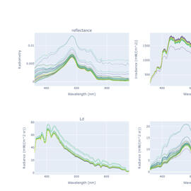
Radiometry Trios
This package allows the manipulation of hyperspectral radiometry measurements from field campaigns, using the TRIOS equipment
https://github.com/cordmaur/RadiometryTrios
Sentinel Downloader
The SentinelDownloader package provides a very simple Python interface to download Sentinel imagery from the Copernicus Open Access Hub. It is a high level object oriented wrapper to the SentinelSat api.
https://github.com/cordmaur/SentinelDownloader
| Other Projects | Description |
|---|---|
| GEES2Downloader | The GEES2Downloader is a simple downloader for S2 imagery from Google Earth Engine. The objective is to overcome the limitations imposed by GEE when downloading assets directly through HTTP protocol. |
| downplanet | Simple Sentinel2 downloader for Microsoft Planetary Computer. |
Information about Courses
The course Introduction to Python for Scientists is currently being taught online and the recorded classes are made available on my YouTube channel.
Playlist: Introduction to Python for Scientists
For information about other courses, please drop me a message.
[email protected]
Contact
You can reach me out on LinkedIn https://www.linkedin.com/in/cordmaur/
Check my articles on Medium: http://cordmaur.medium.com
Browse my projects on GitHub: http://github.com/cordmaur
Propose a collaboration through PeoplePerHour
Or just send me an e-mail at:
[email protected]
31400, Toulouse, France


